
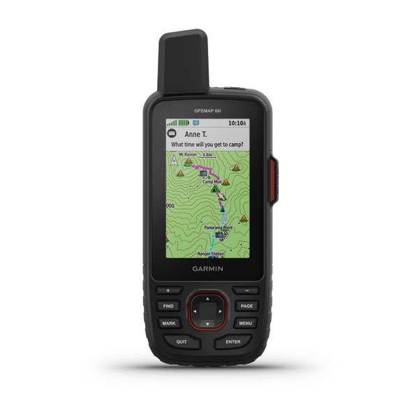


Garmin GPSMAP 66i
MORE ADVENTURE. LESS WORRY.
Precise navigation meets global communication in the rugged GPSMAP 66i button-operated GPS handheld and satellite communicator1 featuring Garmin TopoActive mapping and inReach® technology.
See it in any light. Use it in any conditions. GPSMAP 66i was built for that.
When cellphones can’t connect, inReach can. Communicate with confidence.
Multi-GNSS satellite support puts superior navigation at your fingertips.
Get maps as pretty as a picture and just as detailed —without a subscription.
Know the terrain before you’re in it, with preloaded TopoActive maps of the U.S. and Canada.
Stay out there longer with up to 35 hours of battery life in tracking mode and up to 200 hours in Expedition mode.
General
| PHYSICAL DIMENSIONS | 2.5” x 6.4” x 1.4” (6.2 x 16.3 x 3.5 cm) |
|---|---|
| DISPLAY SIZE | 1.5"W x 2.5"H (3.8 x 6.3 cm); 3" diag (7.6 cm) |
| DISPLAY RESOLUTION | 240 x 400 pixels |
| DISPLAY TYPE | transflective color TFT |
| WEIGHT |
8.1 oz (230 g) with batteries |
| BATTERY TYPE | rechargeable, internal lithium-ion |
| BATTERY LIFE |
up to 35 hours at 10-minute tracking |
| WATER RATING | IPX7 |
| MIL-STD-810 | yes (thermal, shock, water) |
| HIGH-SENSITIVITY RECEIVER | yes |
| INTERFACE | high speed micro USB and NMEA 0183 compatible |
| MEMORY/HISTORY | 16 GB (user space varies based on included mapping) |
Maps & Memory |
|
| PRELOADED MAPS |
yes (TopoActive, routable) |
|---|---|
| ABILITY TO ADD MAPS | yes |
| BASEMAP | yes |
| AUTOMATIC ROUTING (TURN BY TURN ROUTING ON ROADS) | yes |
| MAP SEGMENTS | 15000 |
| BIRDSEYE | yes (direct to device) |
| INCLUDES DETAILED HYDROGRAPHIC FEATURES (COASTLINES, LAKE/RIVER SHORELINES, WETLANDS AND PERENNIAL AND SEASONAL STREAMS) | yes |
| INCLUDES SEARCHABLE POINTS OF INTERESTS (PARKS, CAMPGROUNDS, SCENIC LOOKOUTS AND PICNIC SITES) | yes |
| DISPLAYS NATIONAL, STATE AND LOCAL PARKS, FORESTS, AND WILDERNESS AREAS | yes |
| EXTERNAL MEMORY STORAGE | yes (32 GB max microSD™ card) |
| WAYPOINTS/FAVORITES/LOCATIONS | 10000 |
| TRACKS | 250 |
| TRACK LOG | 20000 points, 250 saved gpx tracks, 300 saved fit activities |
| ROUTES | 250, 250 points per route; 50 points auto routing |
| RINEX LOGGING | yes |
Sensors |
|
| GPS | yes |
|---|---|
| GALILEO | yes |
| BAROMETRIC ALTIMETER | yes |
| COMPASS | Yes (tilt-compensated 3-axis) |
| GPS COMPASS (WHILE MOVING) | yes |
Daily Smart Features |
|
| CONNECT IQ™ (DOWNLOADABLE WATCH FACES, DATA FIELDS, WIDGETS AND APPS) | yes |
|---|---|
| WEATHER | yes |
| VIRB® REMOTE | yes |
| PAIRS WITH GARMIN CONNECT™ MOBILE | yes |
| ACTIVE WEATHER | yes |
| SMART NOTIFICATIONS ON HANDHELD | yes |
Safety and Tracking Features |
|
| LIVETRACK | yes |
|---|---|
Outdoor Recreation |
|
| POINT-TO-POINT NAVIGATION | yes |
|---|---|
| COMPATIBLE WITH BASECAMP™ | yes |
| AREA CALCULATION | yes |
| HUNT/FISH CALENDAR | yes |
| SUN AND MOON INFORMATION | yes |
| XERO™ LOCATIONS | yes |
| GEOCACHING-FRIENDLY | yes (Geocache Live) |
| CUSTOM MAPS COMPATIBLE | yes (500 custom map tiles) |
| PICTURE VIEWER | yes |
| LED BEACON FLASHLIGHT | yes |
inReach® Features |
|
| INTERACTIVE SOS | yes |
|---|---|
| SEND AND RECEIVE TEXT MESSAGES TO SMS AND EMAIL | yes |
| SEND AND RECEIVE TEXT MESSAGES TO OTHER INREACH DEVICE | yes |
| EXCHANGE LOCATIONS WITH OTHER INREACH DEVICE | yes |
| MAPSHARE COMPATIBLE WITH TRACKING | yes |
| VIRTUAL KEYBOARD FOR CUSTOM MESSAGING | yes |
| INREACH REMOTE COMPATIBLE | yes |
Outdoor Applications |
|
| COMPATIBLE WITH GARMIN EXPLORE™ APP | yes |
|---|---|
| GARMIN EXPLORE WEBSITE COMPATIBLE | yes |
Connections |
|
| WIRELESS CONNECTIVITY |
yes (Wi-Fi®, BLUETOOTH®, ANT+®) |
|---|---|